Difference between revisions of "IFR landings"
| (6 intermediate revisions by 3 users not shown) | |||
| Line 2: | Line 2: | ||
=Learning objectives= | =Learning objectives= | ||
| − | # Turn on and configure the ILS | + | |
| − | # Follow the ILS cues | + | #Turn on and configure the ILS |
| − | # Use ground-based TACAN to help set you up for your approach | + | #Follow the ILS cues |
| − | # Understand an approach plate | + | #Use ground-based TACAN to help set you up for your approach |
| + | #Understand an approach plate | ||
=Learning files= | =Learning files= | ||
| − | <embedvideo service="youtube" | + | <embedvideo service="youtube" >https://www.youtube.com/watch?v=DPC8vRnGg2I</embedvideo> |
=T-ILS page= | =T-ILS page= | ||
| Line 23: | Line 24: | ||
When mode selected a steering cue will be displayed in the HUD showing you your course for optimal intercept of the ILS. If you do not wish to use it simply un-mode select CMD STRG with the M-SEL 0 button.<br /> | When mode selected a steering cue will be displayed in the HUD showing you your course for optimal intercept of the ILS. If you do not wish to use it simply un-mode select CMD STRG with the M-SEL 0 button.<br /> | ||
''NOTE:'' On that picture the glideslope is dashed because outside of parameters. | ''NOTE:'' On that picture the glideslope is dashed because outside of parameters. | ||
| − | <gallery widths=460px heights=460px mode="traditional"> | + | <gallery widths="460px" heights="460px" mode="traditional"> |
File:ILS steering cues.jpg| | File:ILS steering cues.jpg| | ||
File:ILS steering cues-final.jpg| | File:ILS steering cues-final.jpg| | ||
</gallery> | </gallery> | ||
| − | All the approach will be made flying the needles and the CMD STRG cue. The CMD STRG cue will guide you horizontally and vertically once within 5°of the ILS cone. If you place the cue into your FPM you will fly a perfect approach. When the glideslope is within 5° | + | All the approach will be made flying the needles and the CMD STRG cue. The CMD STRG cue will guide you horizontally and vertically once within 5°of the ILS cone. If you place the cue into your FPM you will fly a perfect approach. When the glideslope is within 5° the pitch cue will appear on the CMD STRG cue. It’s a large vertical bar on top of the circle. When it is displayed the CMD STRG cue will provide vertical guidance on the glideslope as well. You may see the cue go up or down in your HUD. Each bar has 5 marks. Each represents 2.5°. The optimum position is both bars centred on their middle mark.<br /> |
The HUD symbology will change when the gear is down. The AOA bracket and the minus 2.5° dashed pitch line will be displayed. The heading tape will switch to the top of the HUD.<br /> | The HUD symbology will change when the gear is down. The AOA bracket and the minus 2.5° dashed pitch line will be displayed. The heading tape will switch to the top of the HUD.<br /> | ||
| Line 33: | Line 34: | ||
Note also the inverted V on the heading tape. This cue gives you the wind corrected heading you need to steer to maintain the desired approach course. So if you have the CMD STRG cue under the FPM and the V centred on the heading tape, your nose should be crabbed into the wind just the right amount to maintain ground track along the approach course centreline to the runway.<br /> | Note also the inverted V on the heading tape. This cue gives you the wind corrected heading you need to steer to maintain the desired approach course. So if you have the CMD STRG cue under the FPM and the V centred on the heading tape, your nose should be crabbed into the wind just the right amount to maintain ground track along the approach course centreline to the runway.<br /> | ||
| − | In such situations the HUD can become crowded with information. You can declutter it with the UNCAGE button on the throttle. It will remove some of the symbology on the HUD to give you a cleaner look at your aim point on the runway. The problem | + | In such situations the HUD can become crowded with information. You can declutter it with the UNCAGE button on the throttle. It will remove some of the symbology on the HUD to give you a cleaner look at your aim point on the runway. The problem is that it will also remove the ILS bars so you can see the FPM and the AoA staple and the runway a little more clearly. The declutter will cancel itself with Weight On Wheels if you don't proactively toggle the declutter off again yourself. |
| + | |||
| + | =F-16 ILS landing= | ||
| + | For the purpose of this training we'll use the approach plate of the runway 20 at Kwangju<br /> | ||
| + | approach plates are located in Falcon BMS 4.33\Docs\Airport Approach & Navigation Charts)<br /> | ||
| + | |||
| + | The title let us know that we're looking at the plate of the RWY 20 at Kwangju AB and RWY 20 '''only''' ! (The opposite runway will use an other plate.)<br /> | ||
| + | Many important information are located in the header : | ||
| + | |||
| + | :*TACAN (frequency of the AB TACAN) be advised BMS does not feature ILSDME, so distance is never to the ILS, but to the TACAN or the active steerpoint. | ||
| + | :*TWR : radio frequency of the Tower (UHF and VHF) | ||
| + | :*ILS : Frequency of the ILS | ||
| + | :*ILS DA(H) : Decision Altitude(Height) In our case if we don't have visual on the runway at 200 ft AGL we'll conduct a missed approach procedure. | ||
| + | :*LOC : Localizer heading. This is what you will use as CRS in the T-ILS page. | ||
| + | :*MSA : Minimum Safe Altitude. It gives a topside view of a circle of fixed radius centred on the relevant tacan with safe altitude (MSL) according to quadrants limited by arrival headings. On this example, pilots should notice that the minimal safe altitude is 4900 ft in a radius of 25 Nm of KWA TCN. | ||
| + | :*PAPI - ALSF-1 gives information about the ALS (Approach Lighting System) for that runway and in the case of Papi, the side where the PAPI is located is also given (here PAPI LEFT) | ||
| + | |||
| + | During the training fly to the steerpoint 3 (which is JADOO an IAF holding pattern) at an altitude of 7000 ft then you just have to follow the plate: | ||
| + | |||
| + | :*Fly bearing 235° until DME 12 and start your descent (you should be at 4000 ft at DME12) | ||
| + | :*Start a 12 Nm DME arc at 4000 ft and start to turn left to the RWY passing the R-030° of Kwangju TCN (switch your HSI to TCN/ILS mode) | ||
| + | :*You should now fly to bearing 200°. Adjust your altitude to 2000 ft before DME 9 to intercept the Localizer first and then the Glideslope. We always intercept a glideslope from below to avoid diving to chase it.(Aim for a speed of no more than 220 kts at that time) | ||
| + | :*Now that you have intercepted the glideslope wait for it to centre on the ADI and at that precise time, lower the landing gear and get on the correct speed for landing which usually is around 140 kts but depends on your weight. | ||
| + | :*Final guidance is made by following the steering cues and the AOA indicator until you're able so see the runway. As soon as you're visual you can declutter your HUD using the UNCAGE button to remove DED data and steering cues. If you're reaching the minimums (310 ft or 200 ft AGL) before being able to see the runway then go around and try an other approach or divert to your alternate. | ||
| + | |||
| + | ==F18 carrier ILS landing== | ||
| + | [[File:USNavy CV1 approach to carrier.jpg|thumb|500px|right|Case III approach used during IFR]] | ||
| + | Work In progress ;) | ||
{{Nav UOAF}} | {{Nav UOAF}} | ||
| − | + | ||
| − | [[Category:UOAF]] | + | [[Category:UOAF]] |
| − | [[Category:UOAF: BMS Codex]] | + | |
| + | [[Category:UOAF: BMS Codex]] | ||
Latest revision as of 20:54, 15 July 2019
Contents
Learning objectives
- Turn on and configure the ILS
- Follow the ILS cues
- Use ground-based TACAN to help set you up for your approach
- Understand an approach plate
Learning files
T-ILS page
This page refers to the TACAN and ILS settings. You can access it through the T-ILS ICP button.
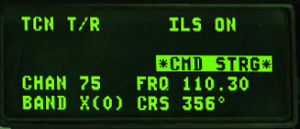
The first line of the DED gives the TCN and ILS status (ILS is turned on/off with the ILS knob on the AUDIO2 panel). The scratchpad is on the left between the two asterisks and that is where the TACAN & ILS frequencies are entered. The system is able to differentiate a valid TACAN channel (0-126) from a valid ILS freq (VHF 4 or 5 digits).
The next line gives the current and active TACAN and ILS frequencies respectively and the last line displays the TACAN band (X or Y) and the CRS set for the ILS approach.
To enter a new TACAN channel or an ILS frequency simply input the relevant numbers within the asterisks and hit ENTR. To change the TACAN band: input 0 (zero) in the scratchpad and press ENTR. That toggles from X to Y to X and so on.
To change the TACAN from T/R (ground domain) to A/A TR (air domain) use the DCS SEQ button.
ILS CMD STRG can be inhibited or activated by placing the scratchpad over it and mode selecting it with the M-SEL 0 ICP pushbutton. The CMD STRG line in the DED is highlighted when command steering is active. To change the ILS course place the scratchpad on the CRS field using DCS up/down and enter the correct runway heading for the active ILS. Press ENTR to input the data into the system.
ILS Steering Cues
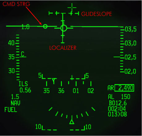
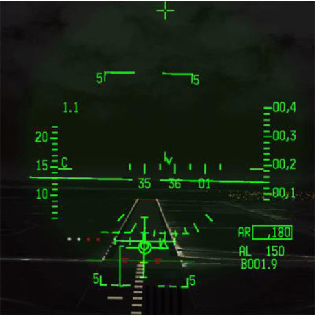
ILS steering cues are turned On and Off in the T-ILS page using the CMD STRG line which you can mode select or not.
When mode selected a steering cue will be displayed in the HUD showing you your course for optimal intercept of the ILS. If you do not wish to use it simply un-mode select CMD STRG with the M-SEL 0 button.
NOTE: On that picture the glideslope is dashed because outside of parameters.
All the approach will be made flying the needles and the CMD STRG cue. The CMD STRG cue will guide you horizontally and vertically once within 5°of the ILS cone. If you place the cue into your FPM you will fly a perfect approach. When the glideslope is within 5° the pitch cue will appear on the CMD STRG cue. It’s a large vertical bar on top of the circle. When it is displayed the CMD STRG cue will provide vertical guidance on the glideslope as well. You may see the cue go up or down in your HUD. Each bar has 5 marks. Each represents 2.5°. The optimum position is both bars centred on their middle mark.
The HUD symbology will change when the gear is down. The AOA bracket and the minus 2.5° dashed pitch line will be displayed. The heading tape will switch to the top of the HUD.
Note also the inverted V on the heading tape. This cue gives you the wind corrected heading you need to steer to maintain the desired approach course. So if you have the CMD STRG cue under the FPM and the V centred on the heading tape, your nose should be crabbed into the wind just the right amount to maintain ground track along the approach course centreline to the runway.
In such situations the HUD can become crowded with information. You can declutter it with the UNCAGE button on the throttle. It will remove some of the symbology on the HUD to give you a cleaner look at your aim point on the runway. The problem is that it will also remove the ILS bars so you can see the FPM and the AoA staple and the runway a little more clearly. The declutter will cancel itself with Weight On Wheels if you don't proactively toggle the declutter off again yourself.
F-16 ILS landing
For the purpose of this training we'll use the approach plate of the runway 20 at Kwangju
approach plates are located in Falcon BMS 4.33\Docs\Airport Approach & Navigation Charts)
The title let us know that we're looking at the plate of the RWY 20 at Kwangju AB and RWY 20 only ! (The opposite runway will use an other plate.)
Many important information are located in the header :
- TACAN (frequency of the AB TACAN) be advised BMS does not feature ILSDME, so distance is never to the ILS, but to the TACAN or the active steerpoint.
- TWR : radio frequency of the Tower (UHF and VHF)
- ILS : Frequency of the ILS
- ILS DA(H) : Decision Altitude(Height) In our case if we don't have visual on the runway at 200 ft AGL we'll conduct a missed approach procedure.
- LOC : Localizer heading. This is what you will use as CRS in the T-ILS page.
- MSA : Minimum Safe Altitude. It gives a topside view of a circle of fixed radius centred on the relevant tacan with safe altitude (MSL) according to quadrants limited by arrival headings. On this example, pilots should notice that the minimal safe altitude is 4900 ft in a radius of 25 Nm of KWA TCN.
- PAPI - ALSF-1 gives information about the ALS (Approach Lighting System) for that runway and in the case of Papi, the side where the PAPI is located is also given (here PAPI LEFT)
During the training fly to the steerpoint 3 (which is JADOO an IAF holding pattern) at an altitude of 7000 ft then you just have to follow the plate:
- Fly bearing 235° until DME 12 and start your descent (you should be at 4000 ft at DME12)
- Start a 12 Nm DME arc at 4000 ft and start to turn left to the RWY passing the R-030° of Kwangju TCN (switch your HSI to TCN/ILS mode)
- You should now fly to bearing 200°. Adjust your altitude to 2000 ft before DME 9 to intercept the Localizer first and then the Glideslope. We always intercept a glideslope from below to avoid diving to chase it.(Aim for a speed of no more than 220 kts at that time)
- Now that you have intercepted the glideslope wait for it to centre on the ADI and at that precise time, lower the landing gear and get on the correct speed for landing which usually is around 140 kts but depends on your weight.
- Final guidance is made by following the steering cues and the AOA indicator until you're able so see the runway. As soon as you're visual you can declutter your HUD using the UNCAGE button to remove DED data and steering cues. If you're reaching the minimums (310 ft or 200 ft AGL) before being able to see the runway then go around and try an other approach or divert to your alternate.
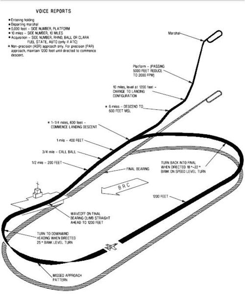
F18 carrier ILS landing
Work In progress ;)
{{#invoke:Navbox|navbox}}
