Difference between revisions of "Bullseye"
m (→BULLSEYE) |
|||
| (18 intermediate revisions by 3 users not shown) | |||
| Line 1: | Line 1: | ||
| − | The ''' | + | [[File:bullseye_map.png||none|400px|left|]]<br /> |
| + | |||
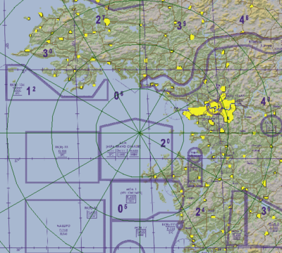
| + | The '''BULLSEYE''' is a fixed reference point on the map that is known to all flights from which the position of an object can be referred to by bearing and range. A position is then referenced like a [[Situational_awareness#BRAA|BRAA]], but relative to the bullseye instead of any plane. | ||
=Learning objectives= | =Learning objectives= | ||
| − | #Understand | + | |
| − | #Understand how to calculate the relative position and distance between two | + | #Understand BULLSEYE |
| + | #Understand how to calculate the relative position and distance between two BULLSEYE references | ||
=Learning files= | =Learning files= | ||
| − | + | <embedvideo service="youtube">https://www.youtube.com/watch?v=6Pe1wDXULr0</embedvideo> | |
| − | = | + | =BULLSEYE= |
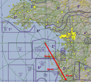
| − | + | [[File:bullseye_range.png|thumb|right|Bullseye ranges in BMS]] | |
| + | In BMS, the BULLSEYE on the map has range rings that cover 30nm out from the center. | ||
| − | + | While BRAA is well and good for telling your flight members where something is, if you need to communicate the position of a bandit to another flight in your package your BRAA call won’t work. The target won’t be at the same bearing and range to the other flight as it is to you. | |
| − | |||
| − | |||
| − | |||
| − | |||
| − | |||
| − | |||
| − | |||
| − | |||
| − | + | In order to solve this, we use a system called a '''BULLSEYE reference'''. The BULLSEYE is a fixed point on the map that is known to all flights. A position is then referenced like a BRAA, but relative to the BULLSEYE instead of any plane. | |
| − | + | For example, a call of ''“Bandit, BULLSEYE two-three-five, ninety-five, twenty-two-thousand”'' means that there’s a bandit 95 miles southwest of the bullseye, flying at 22000 feet. Where this position is relative to your plane depends on where you are relative to the BULLSEYE. | |
| − | + | '''When giving a bullseye position you should always''' | |
| − | + | *'''Use the BULLSEYE proword in your message.''' | |
| + | *'''Bearing is communicated in single digits, “two-two-five thirty”.''' | ||
| + | *'''Range is communicated as a whole number "twenty-five". Avoid using the word "for" in front of the distance, as this can be confused with the number "4".''' | ||
| + | *'''Altitude is communicated as a whole number with "thousand".''' | ||
| + | *'''BULLSEYE should not be truncated to “bull” to avoid it being misinterpreted as “BRAA”.''' | ||
| − | + | Getting used to the BULLSEYE system can be difficult, but it's just a matter of experience. | |
| − | + | ==Understand a BULLSEYE reference== | |
| − | + | #A BULLSEYE reference is a direction and distance from a know fixed point | |
| − | + | ##E.g. "''BULLSEYE zero-two-zero, fifty-one''" is 20 degrees and 51nm away from the BULLSEYE point | |
| − | + | #The BULLSEYE can be anywhere, but you need to know where it is to make sense of a BULLSEYE reference point | |
| − | |||
| − | # A | ||
| − | ## E.g. | ||
| − | # The | ||
==Determining reference location based on geography== | ==Determining reference location based on geography== | ||
| − | # | + | #BULLSEYE is on a fixed location that makes sense in relation to your objective |
#You know your own location in reference to the fixed location | #You know your own location in reference to the fixed location | ||
#You can mentally calculate where a reference location is knowing these two points | #You can mentally calculate where a reference location is knowing these two points | ||
#Easiest to visualize and least amount of work | #Easiest to visualize and least amount of work | ||
| − | #Requires you to know your location in reference to the | + | #Requires you to know your location in reference to the BULLSEYE |
==Determining reference location based on geometry== | ==Determining reference location based on geometry== | ||
| − | [[File: | + | [[File:hsi-bullseye.png|thumb|right|Bullseye on HSI<ref>Dee-Jay, used with permission https://www.bmsforum.org/forum/showthread.php?29794-Bullseye-Calculator&p=415646&viewfull=1#post415646</ref>]] |
| − | [[File:compass_card.png|thumb|right|Compass card]] | + | [[File:bullseye12.jpg|thumb|right|Bullseye example <ref>Ibid.</ref>]] |
| − | # | + | [[File:compass_card.png|thumb|right|Compass card <ref>Ibid.</ref>]] |
| − | #You do not necessarily know your physical location in reference to the | + | |
| − | #Get the reference point in terms of the | + | #BULLSEYE is at an arbitrary location. |
| − | ##This usually comes from AWACS, but flight and package pilots often refer to | + | #You do not necessarily know your physical location in reference to the BULLSEYE. |
| − | #Get your own reference point in terms of the | + | #Get the reference point in terms of the BULLSEYE (e.g. BE 220/30). |
| + | ##This usually comes from AWACS, but flight and package pilots often refer to BULLSEYE locations, especially for hostile contacts. | ||
| + | #Get your own reference point in terms of the BULLSEYE (e.g. BE 150/20). | ||
##You can find this on your HUD, your FCR, or your HSD. | ##You can find this on your HUD, your FCR, or your HSD. | ||
##Note: your heading or the target's heading does not matter; you are going to get the bearing to the target regardless of your own heading. | ##Note: your heading or the target's heading does not matter; you are going to get the bearing to the target regardless of your own heading. | ||
| Line 62: | Line 60: | ||
#Put the furthest reference point (i.e. the point that has the largest distance) on the outside of the compass; this will set the diameter of your compass and is required for the next step. | #Put the furthest reference point (i.e. the point that has the largest distance) on the outside of the compass; this will set the diameter of your compass and is required for the next step. | ||
#Put the closest reference point in the middle of the compass in relation to the radius of your compass. | #Put the closest reference point in the middle of the compass in relation to the radius of your compass. | ||
| − | ##For example, if the first point is 220 | + | ##For example, if the first point is BE 220/30 and the second point is BE 150/20, the distance to the outside of your compass from the center (i.e. the radius) is 30 because it is the largest. The second point is at 20; since the radius is 30, you want to place the second point about 66% away from the center (20/30 = ~66%). |
#Identify the point that represents you. | #Identify the point that represents you. | ||
#Draw an imaginary line between the two points. This will give you the bearing to the reference. The length of the line will give you distance. | #Draw an imaginary line between the two points. This will give you the bearing to the reference. The length of the line will give you distance. | ||
| − | ##So if you are at 150 | + | ##So if you are at BE 150/20 and the target is at BE 220/30, the target is at a rough bearing of 262 degrees (to the west) and is approximately 25nm away. |
#Feel free to use your HSI as a visual aid, but soon you will be able to do this exclusively in your mind quickly with a good degree of accuracy. | #Feel free to use your HSI as a visual aid, but soon you will be able to do this exclusively in your mind quickly with a good degree of accuracy. | ||
| − | #Let's try it again: you are at 097 | + | #Let's try it again: you are at BE 097/8 and the target is as BE 262/12 |
##The target is to the west of you at around 19nm. | ##The target is to the west of you at around 19nm. | ||
| − | ==Notes | + | =Steffan's BULLSEYE orientation helper= |
| + | Let's say you're cruising at BULLSEYE 035/40 and you then get a radio call informing you of the nearest bandit at BULLSEYE 260/60. Not everybody will be able to tell from that how far the bandit is away and at what bearing. | ||
| + | |||
| + | For starters, let's say you are flying north. I have marked the layout on the picture below. The principle is this: just think of the HSI as a top view of the map with the bullseye slap dead in the center. Then, these steps apply: | ||
| + | |||
| + | #Whichever plane is farthest from the BULLSEYE, omit the distance and just keep the bearing. Mentally put that dot on the according degree marker on the outline of the HSI. In this case, it's the bandit at BE 260/60 (red dot). | ||
| + | #Add the other BULLSEYE to the overview. In this case, it's us at BE 035/40. Remember, because we put the bandit on the outer edge, that is our scale. He was 60 miles out, so 40 miles for our position would make that 2/3 from the center to the outline (and towards 35 degrees — blue dot). | ||
| + | #Draw a line between you and the bandit (green dashed line) | ||
| + | #Now shift that line onto the center of the HSI, or our imagined bullseye (green solid line) | ||
| + | |||
| + | Now, because in actuality, our own plane is in the center of the BULLSEYE, we can directly see which bearing we need to fly to go towards the bandit. In this case, it's 250. Also, we can kind of guestimate the distance. It's the full distance of the enemy from the bullseye and a little extra, because we are on the opposite side of the bullseye (in other words, the bullseyes 3-9-line). Let's say it's around 80 miles. | ||
| + | |||
| + | This is all really cool and believe me, you can get quite fast at this with some practice (also, no need to use text markers on your screen :wink:. | ||
| + | |||
| + | But… | ||
| + | |||
| + | There is a problem with this, though. Not always will you be flying directly north. Let's look at the picture if we were flying south instead and didn't adjust our process: | ||
| + | |||
| + | Obviously, it's now telling us we need to fly towards 65 degrees, and that clearly can't be right. Just because our airplane is facing south now, does not mean the entire world has flipped around. Because the HSI is turning with the airplane's direction, we need to rotate the mental picture accordingly: | ||
| + | |||
| + | With this in mind, it could be any direction and the process will always work. | ||
| + | |||
| + | =Notes= | ||
<references /> | <references /> | ||
| + | |||
| + | {{Nav UOAF}} | ||
[[Category:UOAF]] | [[Category:UOAF]] | ||
[[Category:UOAF: BMS Codex]] | [[Category:UOAF: BMS Codex]] | ||
Latest revision as of 07:36, 20 June 2024
The BULLSEYE is a fixed reference point on the map that is known to all flights from which the position of an object can be referred to by bearing and range. A position is then referenced like a BRAA, but relative to the bullseye instead of any plane.
Contents
Learning objectives
- Understand BULLSEYE
- Understand how to calculate the relative position and distance between two BULLSEYE references
Learning files
BULLSEYE
In BMS, the BULLSEYE on the map has range rings that cover 30nm out from the center.
While BRAA is well and good for telling your flight members where something is, if you need to communicate the position of a bandit to another flight in your package your BRAA call won’t work. The target won’t be at the same bearing and range to the other flight as it is to you.
In order to solve this, we use a system called a BULLSEYE reference. The BULLSEYE is a fixed point on the map that is known to all flights. A position is then referenced like a BRAA, but relative to the BULLSEYE instead of any plane.
For example, a call of “Bandit, BULLSEYE two-three-five, ninety-five, twenty-two-thousand” means that there’s a bandit 95 miles southwest of the bullseye, flying at 22000 feet. Where this position is relative to your plane depends on where you are relative to the BULLSEYE.
When giving a bullseye position you should always
- Use the BULLSEYE proword in your message.
- Bearing is communicated in single digits, “two-two-five thirty”.
- Range is communicated as a whole number "twenty-five". Avoid using the word "for" in front of the distance, as this can be confused with the number "4".
- Altitude is communicated as a whole number with "thousand".
- BULLSEYE should not be truncated to “bull” to avoid it being misinterpreted as “BRAA”.
Getting used to the BULLSEYE system can be difficult, but it's just a matter of experience.
Understand a BULLSEYE reference
- A BULLSEYE reference is a direction and distance from a know fixed point
- E.g. "BULLSEYE zero-two-zero, fifty-one" is 20 degrees and 51nm away from the BULLSEYE point
- The BULLSEYE can be anywhere, but you need to know where it is to make sense of a BULLSEYE reference point
Determining reference location based on geography
- BULLSEYE is on a fixed location that makes sense in relation to your objective
- You know your own location in reference to the fixed location
- You can mentally calculate where a reference location is knowing these two points
- Easiest to visualize and least amount of work
- Requires you to know your location in reference to the BULLSEYE
Determining reference location based on geometry
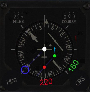
- BULLSEYE is at an arbitrary location.
- You do not necessarily know your physical location in reference to the BULLSEYE.
- Get the reference point in terms of the BULLSEYE (e.g. BE 220/30).
- This usually comes from AWACS, but flight and package pilots often refer to BULLSEYE locations, especially for hostile contacts.
- Get your own reference point in terms of the BULLSEYE (e.g. BE 150/20).
- You can find this on your HUD, your FCR, or your HSD.
- Note: your heading or the target's heading does not matter; you are going to get the bearing to the target regardless of your own heading.
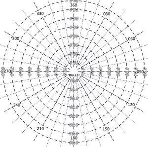
- Picture a compass in your mind.
- Put the furthest reference point (i.e. the point that has the largest distance) on the outside of the compass; this will set the diameter of your compass and is required for the next step.
- Put the closest reference point in the middle of the compass in relation to the radius of your compass.
- For example, if the first point is BE 220/30 and the second point is BE 150/20, the distance to the outside of your compass from the center (i.e. the radius) is 30 because it is the largest. The second point is at 20; since the radius is 30, you want to place the second point about 66% away from the center (20/30 = ~66%).
- Identify the point that represents you.
- Draw an imaginary line between the two points. This will give you the bearing to the reference. The length of the line will give you distance.
- So if you are at BE 150/20 and the target is at BE 220/30, the target is at a rough bearing of 262 degrees (to the west) and is approximately 25nm away.
- Feel free to use your HSI as a visual aid, but soon you will be able to do this exclusively in your mind quickly with a good degree of accuracy.
- Let's try it again: you are at BE 097/8 and the target is as BE 262/12
- The target is to the west of you at around 19nm.
Steffan's BULLSEYE orientation helper
Let's say you're cruising at BULLSEYE 035/40 and you then get a radio call informing you of the nearest bandit at BULLSEYE 260/60. Not everybody will be able to tell from that how far the bandit is away and at what bearing.
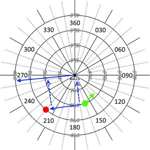
For starters, let's say you are flying north. I have marked the layout on the picture below. The principle is this: just think of the HSI as a top view of the map with the bullseye slap dead in the center. Then, these steps apply:
- Whichever plane is farthest from the BULLSEYE, omit the distance and just keep the bearing. Mentally put that dot on the according degree marker on the outline of the HSI. In this case, it's the bandit at BE 260/60 (red dot).
- Add the other BULLSEYE to the overview. In this case, it's us at BE 035/40. Remember, because we put the bandit on the outer edge, that is our scale. He was 60 miles out, so 40 miles for our position would make that 2/3 from the center to the outline (and towards 35 degrees — blue dot).
- Draw a line between you and the bandit (green dashed line)
- Now shift that line onto the center of the HSI, or our imagined bullseye (green solid line)
Now, because in actuality, our own plane is in the center of the BULLSEYE, we can directly see which bearing we need to fly to go towards the bandit. In this case, it's 250. Also, we can kind of guestimate the distance. It's the full distance of the enemy from the bullseye and a little extra, because we are on the opposite side of the bullseye (in other words, the bullseyes 3-9-line). Let's say it's around 80 miles.
This is all really cool and believe me, you can get quite fast at this with some practice (also, no need to use text markers on your screen :wink:.
But…
There is a problem with this, though. Not always will you be flying directly north. Let's look at the picture if we were flying south instead and didn't adjust our process:
Obviously, it's now telling us we need to fly towards 65 degrees, and that clearly can't be right. Just because our airplane is facing south now, does not mean the entire world has flipped around. Because the HSI is turning with the airplane's direction, we need to rotate the mental picture accordingly:
With this in mind, it could be any direction and the process will always work.
Notes
<references />
{{#invoke:Navbox|navbox}}
